Published · By Sailing Beyond Limits
2027 Solar Eclipse in Spain: Weather Strategy, Cloud Cover Maps & Microclimate Analysis
An in-depth meteorological guide analyzing historical cloud cover, coastal microclimates, Levante winds, and why maritime viewing offers the highest weather resilience for the August 2, 2027 eclipse.
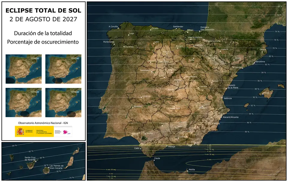
When the 2 August 2027 total solar eclipse crosses southern Spain, the umbra will sweep the Strait of Gibraltar in mid-morning. At Sotogrande / San Roque the Instituto Geográfico Nacional (IGN) lists about 4 minutes 17 seconds of totality (more than 4 minutes), from roughly 10:45:30 to 10:49:47 CEST, with maximum near 10:47:38. The Sun stands at about 38.5° elevation, azimuth ~96°. Spain’s national maximum is 4 minutes 48 seconds in Ceuta. Partial phases run approximately 09:41–12:01. Check any coastal pin on the IGN map if you need that window for a different coordinate; the flotilla’s sea point is 10:45:49 CEST · 4m 17s. To watch from the water with room to move if cloud forms, book a seat.
Western Europe has no other mainland seat of totality in 2027. That geography is why Andalusia is already on every eclipse-chaser shortlist. The second question is harder: will the sky be clear at 10:47?
August climatology along the Cádiz–Málaga arc is among the most favourable in Europe: a strong subtropical high, long sunshine and very little rain. Experienced mariners and local forecasters still treat that as a base rate, not a guarantee. What hides the corona is almost never a classic Atlantic front. It is a microclimate — a ridge Cu, a Levante haze, a beach-level veil — sitting on your viewing point for four minutes.
This guide walks through the meteorology, the marine boundary layer, and why a licensed boat 1–3 nautical miles off Puerto Deportivo de Sotogrande is the most resilient weather strategy on this coast.
1. Historical climate: why southern Spain is the European favourite
Early August in Andalusia is dominated by the Azores High (the North Atlantic subtropical anticyclone). Subsiding, drying air aloft suppresses deep convection over a wide region. That is the physical reason the Costa del Sol and Campo de Gibraltar feel “endlessly blue” in high summer.
What can be said without inventing satellite percentages:
- Sunshine. August is the peak sunshine month on this coast. Bright days with long photoperiods are the rule, not the exception.
- Rain. Measurable rain on 2 August is unusual. A classic mid-latitude frontal cloud shield is not the default failure mode.
- Cloud type. When cloud does appear near mid-morning, it is typically fair-weather cumulus, orographic scraps over sierras, or low marine stratus / haze tied to Strait flow — not a solid overcast from a passing low.
Macro climate maps (and many “clear-sky probability” graphics shared online) average over large grid cells. They smear out the 2 km of coastline where you actually stand. A 10 km satellite pixel can be “mostly clear” while a Cumulus humilis sits exactly on your ridge, or while Levante haze hugs the Tarifa–Algeciras shore.
Takeaway: use Andalusia’s August sunshine as the reason to come here, then plan for the last 20 kilometres and the last 60 minutes.
2. Microclimates that can still hide the Sun at ~10:45 CEST
Totality is short. The IGN window at Sotogrande is ~4m 17s. You do not need a storm. You need one opaque patch on the solar disk for those minutes. Three mechanisms matter on this coast.
A. Radiative heating and convective Cu over the sierras
After sunrise, dark rock and dry soil heat faster than the sea. Along the Sierra de Grazalema (inland of the Strait) and the Sierra Blanca / Sierra de las Nieves hinterland behind Marbella and Estepona, warm air rises. By late morning that lift often organises into fair-weather cumulus (Cumulus humilis or mediocris) over ridgelines.
Because the Sun is already at ~38.5°, a cloud over a peak inland of you can still occult the disk if it sits on the line of sight. Land observers on hills “for a better view” sometimes put themselves into the Cu factory. Beaches at the foot of a heated slope can inherit the same field as it drifts seaward.
Timing is unkind: convection often wakes up between 10:00 and 12:00 — exactly the totality window.
B. Levante, the Strait gap, and marine haze
The Strait of Gibraltar is a wind tunnel. An easterly Levante (Spanish) / Chergui-side flow through the gap accelerates, mixes, and can pile marine boundary-layer moisture against the European shore.
Effects that mariners know well:
- A low veil or coastal stratus along Tarifa, Algeciras Bay, Gibraltar and, in some setups, pockets toward the Sotogrande–Estepona strip.
- Haze and reduced transparency even when the sky is not “cloudy” in the forecast-app sense — bad for corona photography, still a problem for visual observers.
- Rapid onshore/offshore differences: 2–3 miles to seaward can sit in clearer air while the beach is milky.
Levante is not guaranteed on 2 August 2027; it is a known failure mode. Any 2027 briefing that ignores Strait gap flow is incomplete.
C. Urban heat, dust and optical seeing
Coastal towns (Estepona, Marbella, the Bay of Algeciras) add heat-island turbulence, traffic aerosol and, in dry spells, calima (dust). That rarely blocks totality the way a Cu does, but it degrades seeing: the corona looks softer, high-resolution imaging suffers, and the sky near the Sun can look milky.
A deck over open water, upwind of the worst exhaust and with a 360° horizon, is optically quieter than a packed promenade.
3. Land point vs. marine boundary layer
The marine boundary layer (the lowest kilometre or so over the sea) behaves differently from the inland mixed layer. That is not marketing; it is textbook coastal meteorology.
- Thermal inertia of water. The Mediterranean surface temperature changes slowly through a morning. Land surface temperature does not. Over water you get far less surface-triggered convection, so the classic 10:30 Cu field is an inland phenomenon first.
- More stratified, smoother air. Over a relatively uniform cool sea, the lowest layers stay more stable. “Seeing” (scintillation) is often better than over sun-baked tarmac and rock — relevant if you care about corona structure, not only “was it dark.”
- Distance from orographic lift. 1–3 nautical miles off Puerto Sotogrande typically puts you outside the shade of ridge Cu that grows over the sierras. You are also offset from the worst beach-hugging stratus if Levante pins moisture to the shore.
None of this makes the sea magically cloud-free. A thick Strait stratus can still exist over water. It does mean the conditional risk of “land-only” Cu and heat haze is lower, and that you can move if the shore goes milky.
At the marina itself, IGN duration remains ~4m 17s — more than 4 minutes of corona, glasses ISO 12312-2 for every partial phase, naked eye only in totality.
4. Nautical mobility: the variable land cannot match
The structural weakness of a Tarifa beach, a roadside lay-by or an inland mirador is spatial fixation. If a bank slides over you at 10:40, you have five minutes and no road. August traffic on the A-7 / N-340 corridor is not a weather instrument.
A skippered charter from Puerto Deportivo de Sotogrande is a weather platform:
- Horizon intelligence. A 360° sea horizon lets the crew see haze and Cu arriving, not only overhead.
- Short reposition. A few nautical miles at displacement speed is often enough to leave a coastal puff or a shoreline veil. That is a 10–20 minute decision, not a 90-minute traffic jam.
- Umbral theatre. The shadow racing over water is part of the astronomy: you watch the umbra approach on a clean foreground, not behind apartment blocks.
Practical protocol for the morning of 2 August (not a promise of clear sky — a decision loop):
- Pre-dawn: check synoptic chart (Azores High vs. any unusual trough), Strait wind (Levante vs. Poniente vs. slack), and satellite loop for low cloud in the gap.
- 08:00–09:00: embark as planned (flotilla product: activity start 09:00; arrive one hour before). Reassess haze over the African and European shores.
- 09:30–10:30: if beach-level stratus or a Cu line sits on the coast, favour a slightly more seaward or along-shore holding area while remaining in the umbra (duration still more than 4 minutes near Sotogrande; do not “chase seconds” onto a sandbar of cloud).
- 10:45–10:50: totality. ISO 12312-2 off only for those ~4m 17s; diamond ring (C3) and glasses back on.
Radar, satellite and VHF help; eyeballs and local knowledge of the Strait still matter more than a phone app pixel.
5. What this does not claim
Honest meteorology for 2027:
- We do not quote a fake “93% chance of clear skies.” Climatology is favourable; the hour of totality is still a nowcast.
- We do not invent millimetre-rain probabilities for a single date.
- We do not tell you Tarifa’s extra seconds of duration beat a mobile deck if Levante hazes the beach.
- Hills do not block this eclipse at Sotogrande: the Sun is high enough (~38.5°). The real enemy is low cloud and haze on a fixed point.
6. Strategy in one paragraph
Come to southern Spain because August under the Azores High is the best large-scale setup in mainland Europe. Then refuse to bet those four minutes on a single GPS pin. Pair IGN’s ~4m 17s at Sotogrande with a marine boundary layer and a skipper who can still move. That is the highest-resilience weather plan on this coast — not because the sea is always empty of cloud, but because it is cooler, smoother, farther from orographic Cu, and not stuck in the A-7.